
Rwanda is known as the land of 1000 hills, so what better way to explore its natural beauty than get out in them. 4 easy to follow online maps guide you through villages, across canopy bridges and to magnificent churches, letting you explore and admire at your own pace. Whether you are just beginning your hiking journey or are an intermediate explorer, Azizi Life routes have something for you right from our front door! Ever wondered where some of your favourite tropical fruits come from? What flowers can heal the sick, or what sacred stories Rwanda’s nature holds? Azizi life routes will give you all the answers, a unique cultural immersion and fond memories, so join us today!
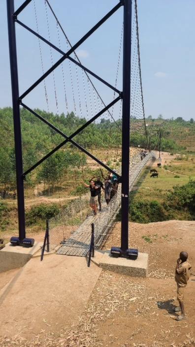


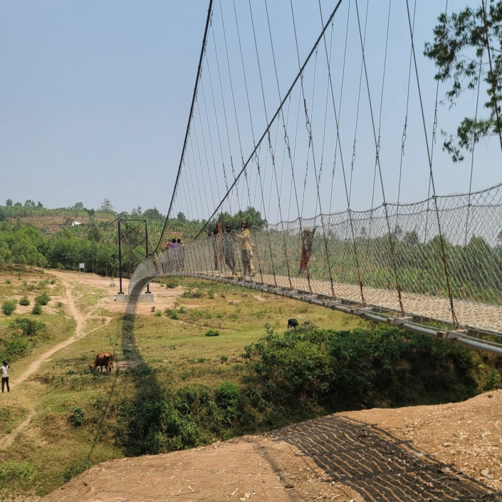
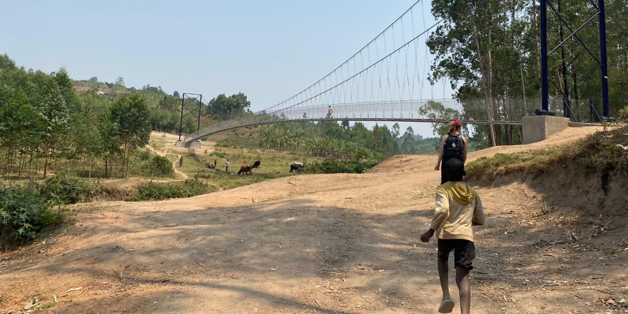
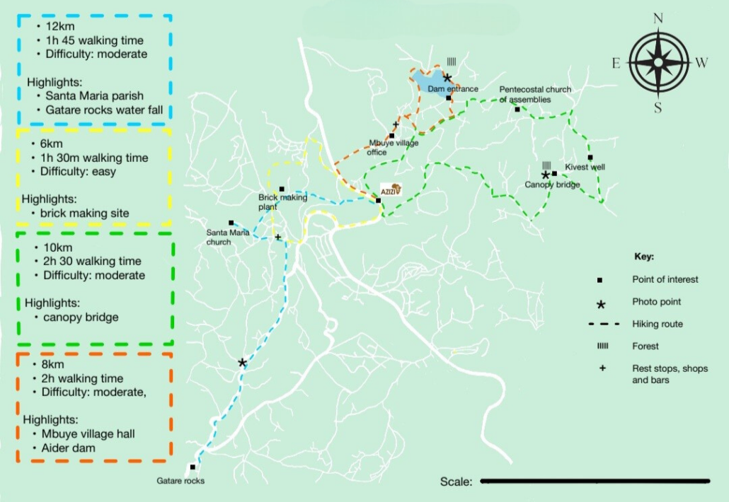
With the Green Hike embark on a journey to the canopy bridge, a stunning pathway that weaves through verdant landscapes and scenic views of the surrounding nature. This includes the Aider Dam, farmlands, and finally the exciting Nyagashanga suspension bridge. You will also pass through rural villages, around houses, water pumps and outdoor toilets used by the locals, so catch a breath and enjoy a moment of tranquillity as you connect to the local community. Spanning a total distance of 10.4km, with an estimated time to complete of 2 and a half hours, you’ll have the opportunity to pause to take in the sights as well as take photos.
Stops:
- Hope of Family: A NGO that supports local families in healthy eating and nutritional knowledge.
- Kinvest Well: An underwater well funded by Kinvest Impact education to provide clean water.
- Nyagashanga susppension bridge: An impressive canopy bridge crossing the border between Muhanga district and Ruhango district.
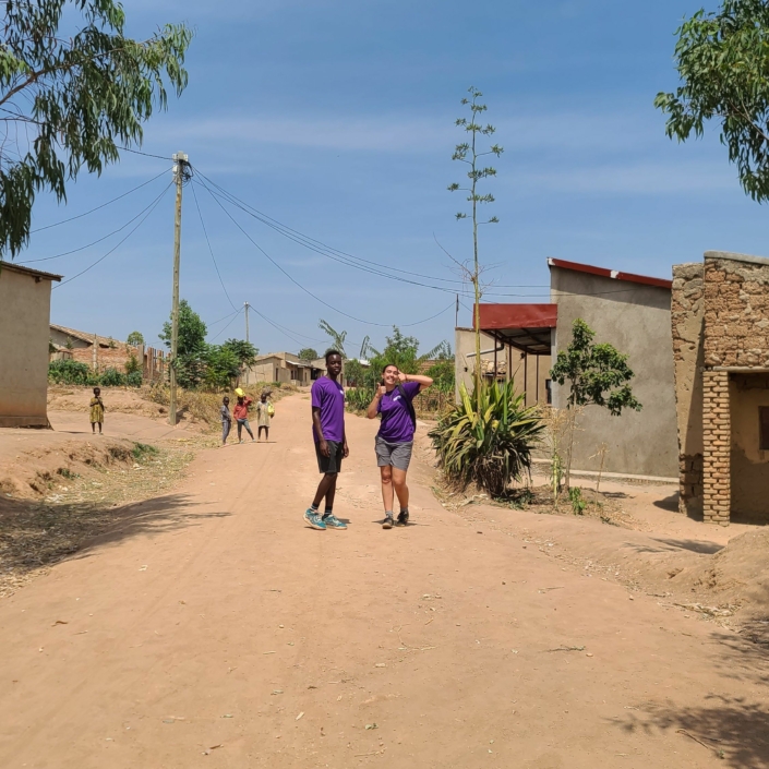
The Yellow Hike is a 6km loop passing through Rugerero village which highlights the day-to-day workings of local life, passing by shops, bars, a leather works as well as a brick making plant. The trail is easy to follow and remains on dirt roads and stone paths.
Stops:
- Byimana genocide memorial: A memorial to commemorate the 1994 genocide against the Tutsi.
- Byimana centre: Passing the hub of the sector with many local bars, shops and a leather merchants workshop.
- Brick Making: Passing by a brick production and drying towers.
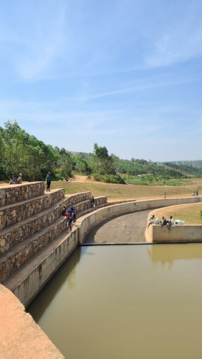
The Red hike takes you on a varied route, passing by Mbuye village office, The Pentecostal Assemblies church of Rwanda, and ending with AIDER dam. The 7.6km walk starts on the main road but turns quicky into the village, where you become surrounded by fruit trees and are greeted by local children. The Pentecostal church is just off the path, and when opened gives a glimpse into the religious belief and its role in the community. The easy but rocky path leads you all the way to the dam where you may find people fishing and swimming so feel free to explore while being mindful of your safety and respectful to the security guards. This hike gives you the opportunity to explore nature and cultivation, with many plants featured in our botanical booklet, as well as cranes and hawks sometimes drinking from the dam. With lovely photo sports and ample places to rest and relax, the red hike is perfect for beauty spot lovers.
Stops:
- Pentecostal Assemblies church of Rwanda: Founded 10 years ago with a congregations size of about 150.
- Muhororo cell (village) office: Opened in 2004 and provided community services such as records for births & deaths as well as conflict resolution and village development.
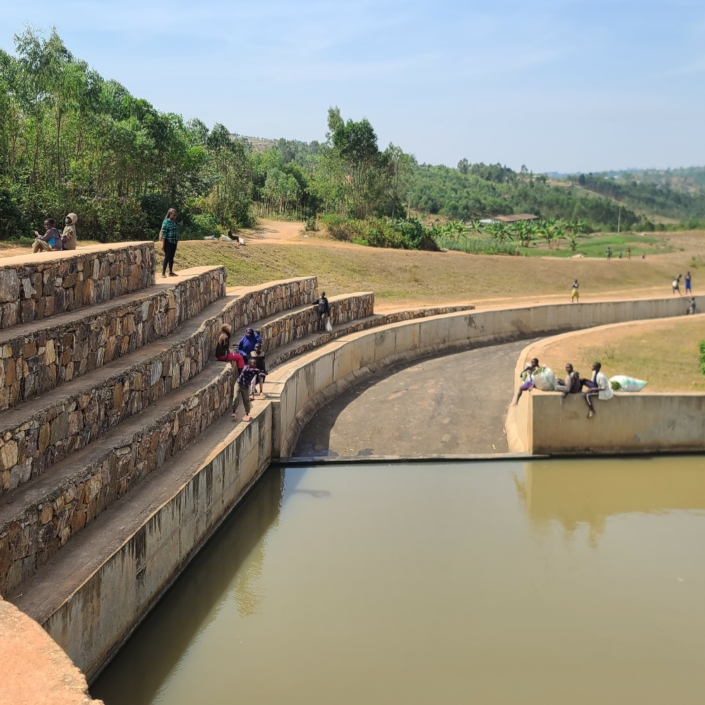
- Aider dam: A man made dam that supplies clean water to 4 districts and even across to Burundi.
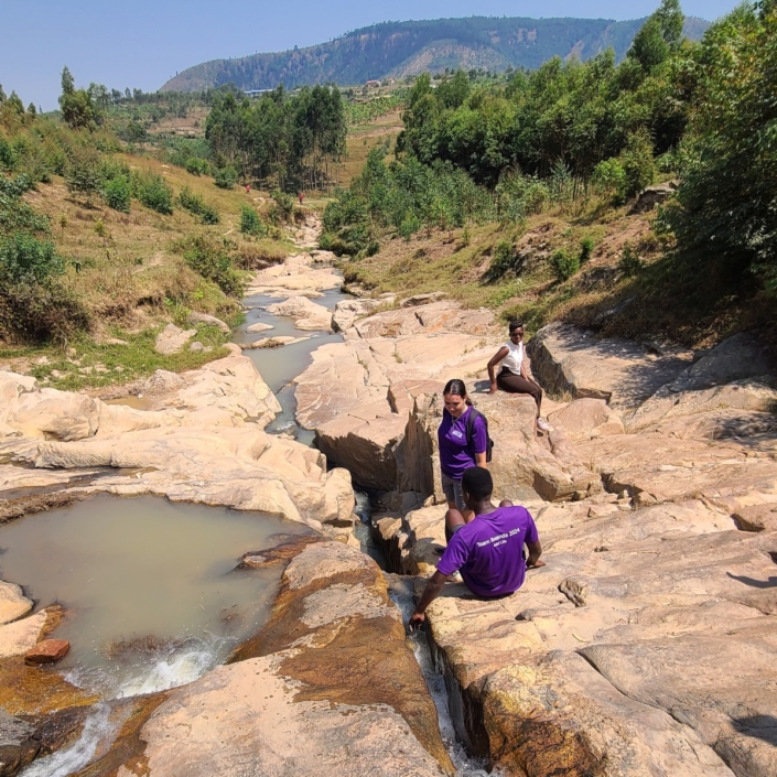
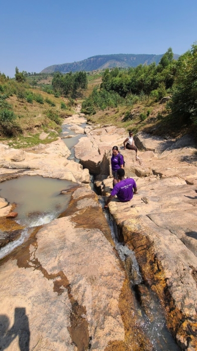
Our blue hike will take you on an enlightening and spiritual journey as you pass through the local farmland, Santa Maria Parish, Byimana centre and then finally reach Gatare rocks where there is a serene water stream The hike is approximately 11.7km in length and takes about 3 hours to complete. At the beginning of the hike you will get to see the local people cultivating the farmlands where you can even stop and talk to some of the farmers and practice your Kinyarwanda. Keep walking and you will reach an evergreen forest that includes pine trees and trees with multiple stumps. On your first stop you will pass Santa Maria Parish which was refurbished in 2019 and can host up to 2,500 people. Continuing on the hike you will pass Byimana centre where you can visit a range of bars and shops and use other services such as banks, and visit the local cell office. You will then reach a straight road that leads down to a mining sector where you will see breathtaking views of the Saruheshyi mountains. On your left you will see the open quarry for the Ruhango district where many elements are mined. Finally you will reach Gatare rocks where there is a downhill streams where you can dip your feet and take scenic pictures!
Stops:
- Santa Maria parish/Byimana cathedral: Expanded in 2023 to accommodate 2,500 people and includes a statue of the Virgin Mary.
- Saruheshyi Mountain View: Beautiful views of distant mountains and an open quarry, part of Ruhango’s mining sector.
- Gatare rocks: A rocky stream, which strethces down to the mountain foothills, where locals wash clothes and children play.
Welcome to Azizi Life hiking, we’re so excited that you’ve chosen to explore what beautiful Ruhango has to offer! Whilst these walks are self-directed allowing you to discover at your own pace, this pre-departure hike guide is here to support you with some recommendations and tips. By reading this document, we believe you will be better prepared to enjoy yourself in a safe way.
Blue Hike: Easy, 7km (Santa Maria Parish, Gatare rocks waterfall)
Green Hike: Moderate, 10km (Canopy Bridge, Pine tree forest)
Red Hike: Moderate, 7.6km (Mbuye village hall, Aider Dam)
Yellow Hike: Easy, 5km (Village centre, Brickmaking)
How to prepare:
Regardless of which Azizi route you’ve chosen, being well prepared is a must for any terrain or hiking experience level.
- Pack plenty of water (free filtered water is available from the Azizi Life café).
- Wear close-toed shoes
- The Sun is hot so bring sunscreen & a hat
- Hand sanitizer
All Trails Guide
Our hikes are plotted on the all trails app for your convenience, allowing you to follow the trails using GPS. Scan the QR code or click on it and it will take you to the relevant “All Trails” web page
Here is a short guide to using the app so you feel confident along your journey.
- Download app + follow the trail for free.
- It acts like google maps, using GPS to track your position.
- It saves your progress and tracks where you’ve been.
- Start at the green dot and end at the black dot.
- As you follow the blue route, you will plot your own green route showing exactly where you have been.
- The route also has small white arrows that highlight your direction of travel for extra reassurance.
- You can access a description and photos before you start the route to understand more about what you will see and experience.
If you prefer to walk with a guide just contact expereinces@azizilife.com to get the prices and book one.
Safety Information
Hiking involves inherent risks, including but not limited to, rough terrain, weather conditions, wildlife encounters, and physical exertion. It is your responsibility to assess your physical fitness and health before embarking on this trail. You are responsible for your own safety and that of any minors or dependents accompanying you. Please carry appropriate equipment, such as water, proper footwear, and first aid supplies, and be prepared for changing weather conditions.
Be aware of your physical abilities – Rwanda can be as hot as 35 degrees.
Respecting the Hiking Routes
- Please practice Leave No Trace principles. Respect the natural environment and wildlife by staying on designated paths, disposing of waste properly, and minimizing your impact on the ecosystem.
- Abide by the hiking routes provided by Azizi Life to avoid trespassing on private land.
- Do not litter. There are bins located outside Azizi Life.
Emergency contacts
- In the event of an emergency, contact local emergency services immediately on 112
- Phone reception may be limited or unavailable in some areas of the trail. If that is the case try to locate the nearest cell (cluster of houses) and seek help there.
Disclaimer
The trail operators, landowners, and any associated entities or individuals are not liable for any injuries, damages, or losses that may occur during your hike. This includes, but is not limited to, accidents, injuries, property loss, or other unforeseen incidents.